
BIAFRA: THE BIGHT OF BIAFRA, NIGER DELTA AND BRITISH GOVERNMENT SYSTEM OF DIVIDE AND RULE (PART 1)
By Mazi Nnebedum Nwachinemelu
March 21, 2017
The aim of this article is to expose the divide and rule antics of the Bristish government; in collaboration with some corrupt minded elements from Yoruba land and Hausa-Fulani oligarqy against the indigenous people of Biafra for decades.
It is a well known facts without disputation that everybody from the old Eastern part of Nigeria; today known as South East and South South were mainly identified as indigenous people of Biafra during the earlier colonial movement in Africa.
Over the weekend I conducted a research in my family library; I was astonished when i came across a book named "PATHFINDER ATLAS FOR WEST" with this book I was able to gather some beneficial information to help drive home my points towards educating this generation to know the hidden secret or information about Biafra from this old book produced by the British.
This book was printed and bound in Great Britain by "Collins Clear-Type Press" and its first edition was published in: November 1948 and the ninth and eleventh editions were printed in July 1960 and July 1962 respectively.
The book was Produced under the direction of a joint advisory board which includes; K.H.Huggins,PH.D.(Geograpgical), G.B.Young, F.R.G.S.(Technical), B.A.Workman,M.A (Educational), J.Gallow(Editorial).
This atlas was used by my father during his early school days before Nigeria gained her independence on 1st of October, 1960 from Britain to function as an amalgamated country; this might be the sole or core reason(s) why Nigeria banned history as a subject from her academic curriculum.
Page twenty three (23) of this book where the map of Eastern and Western regions of Nigeria was drawn, in it was boldly written at the coastline "BIGHT OF BIAFRA". This bight; (a bend in coastline) runs from shoreline of present day Delta State all the way down to Cross River State. First information to note here is how the river and her Atlantic tributaries run; from Oceanography a river or ocean course determine the the geographical area of that area which simply implies that the area between the ocean end and land(shoreline) was known to be the Bight of Biafra.
Now the question to ask here is….. Why the name bight of Biafra given to that geographical area?
What is the real name of the people habituating within this area? If the people who lived in these areas were not originally known to be Biafrans.
Its now a well known fact that after the Nigeria/Biafra civil war; a lot of efforts were made by the British Government and their Nigerian counterparts to obliterates anything that connotes with Biafra and rewrite the history of the good, peace and loving people of Biafra.
One of the methods deployed by the Nigerian government towards re-writing the history of Biafra and possibly utilize their divide and rule tactics was in order to create division amongst Biafrans; they caved out some parts of old Eastern Nigeria to this day christened South South, a term that is alien in geographical position.
This they achieved through the creation of more states out of the old eastern region during and immediately after the civil war; an approach well mastered and used by the Bristish government during the colonial dispensation. The military governments of Nigeria mostly northerns (Hausa-Fulani) extraction in collaboration with their Yorubas acolytes capitalized on this approach to further slice the old Eastern region in a bit to cause disunity and disharmony amongst brothers with the use of military decrees.
Immediately after the civil war, the "BIGHT OF BIAFRA" was changed to mean "BIGHT OF BONNY". Another strategy to obliterate Biafra from history books. This has become evident in page twenty nine of subsequent editions of same Collins Longman Atlas produced by the British in unison with some Yorubas.
This time the Atlas is Titled SENIOR SECONDARY SCHOOL ATLAS. This Atlas was first published in 1983 with a cartographer of the Nigerian map section in the person of PROFESSOR OLAYINKA BALOGUN of the department of Geography, University of Lagos State Nigeria. After this malicious act was carried out caused most Igbo speaking parts of Biafra to have some kind of resentment/sentiments towards the Yorubas due to the part they played during and after the civil war.
The question here is:- Did it not occur to this Yoruba Professor of geography that the area he changed to mean Bight of Bonny is a calculated attempt to re-write the history of Biafra in other words set in confusion amongst brothers?
Why the sudden and urgent need for the creation of South-South out of old Eastern part of Nigeria by Jack Gowon and his Northern military brothers who sees this area as their core heritage?
Was there any form of plebiscite conducted in the old Eastern Nigeria to create South-South separating kith and kin from their heritage?
Has State creation solved any major developmental problems in the now South-East and South-South states? The clear answer to these questions is a big NO.
We were told by the British with the help of Hausa-Fulani and the Yoruba media that the Igbo speaking parts of Biafra went to war in order to colonize and exploit the natural resources of the area they called “South-South or Niger Delta”, but the BIG question here isl; Who owns, control and exploit the 95% of the oil wells in the so called Niger Delta?
If you are from this region and can give us genuine answer(s) to these question(s); then your road to REDEEMPTION is not far from where you are presently.
But thanks goodness for the good works of Indigenous People of Biafra (IPOB) led by Mazi Nnamdi Kanu who is currently being held illegally by the Nigerian govt and his works on Radio Biafra/Biafra Television.
IPOB is currently doing a great work towards proper public enlightenment on the true history of Biafra and the unification of old Eastern part of Nigeria towards the restoration of sovereign Nation of Biafra.
To be continued…
#FreeNNAMDIKANU
#Biafrexit
#Referendum
Editor/Publisher: Chinwe Korie
Twitter: @ckorie17
Facebook: facebook.com/ckorie17
Email: ckorie17@gmail.com
By Mazi Nnebedum Nwachinemelu
March 21, 2017
The aim of this article is to expose the divide and rule antics of the Bristish government; in collaboration with some corrupt minded elements from Yoruba land and Hausa-Fulani oligarqy against the indigenous people of Biafra for decades.
It is a well known facts without disputation that everybody from the old Eastern part of Nigeria; today known as South East and South South were mainly identified as indigenous people of Biafra during the earlier colonial movement in Africa.
 |
| Pathfinder Atlas for West Africa |
This book was printed and bound in Great Britain by "Collins Clear-Type Press" and its first edition was published in: November 1948 and the ninth and eleventh editions were printed in July 1960 and July 1962 respectively.
The book was Produced under the direction of a joint advisory board which includes; K.H.Huggins,PH.D.(Geograpgical), G.B.Young, F.R.G.S.(Technical), B.A.Workman,M.A (Educational), J.Gallow(Editorial).
This atlas was used by my father during his early school days before Nigeria gained her independence on 1st of October, 1960 from Britain to function as an amalgamated country; this might be the sole or core reason(s) why Nigeria banned history as a subject from her academic curriculum.
 |
| Map showing Bight of Biafra befor Biafra vs Nigeria war |
Now the question to ask here is….. Why the name bight of Biafra given to that geographical area?
What is the real name of the people habituating within this area? If the people who lived in these areas were not originally known to be Biafrans.
Its now a well known fact that after the Nigeria/Biafra civil war; a lot of efforts were made by the British Government and their Nigerian counterparts to obliterates anything that connotes with Biafra and rewrite the history of the good, peace and loving people of Biafra.
One of the methods deployed by the Nigerian government towards re-writing the history of Biafra and possibly utilize their divide and rule tactics was in order to create division amongst Biafrans; they caved out some parts of old Eastern Nigeria to this day christened South South, a term that is alien in geographical position.
This they achieved through the creation of more states out of the old eastern region during and immediately after the civil war; an approach well mastered and used by the Bristish government during the colonial dispensation. The military governments of Nigeria mostly northerns (Hausa-Fulani) extraction in collaboration with their Yorubas acolytes capitalized on this approach to further slice the old Eastern region in a bit to cause disunity and disharmony amongst brothers with the use of military decrees.
 |
| Map showing Bight of Bonny; Created after the Biafra vs Nigeria war |
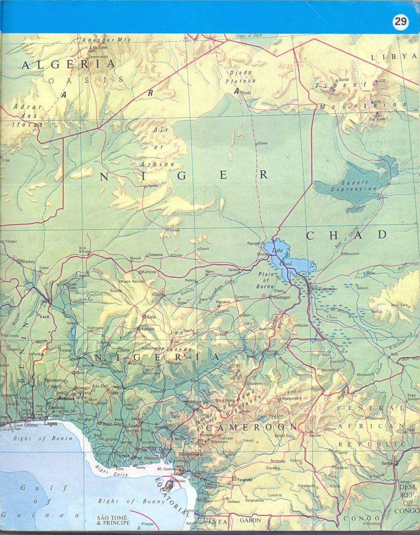 |
| Alas map showing the concocted Bight of Bonny instead of the 'Original' Bight of Biafra |
The question here is:- Did it not occur to this Yoruba Professor of geography that the area he changed to mean Bight of Bonny is a calculated attempt to re-write the history of Biafra in other words set in confusion amongst brothers?
Why the sudden and urgent need for the creation of South-South out of old Eastern part of Nigeria by Jack Gowon and his Northern military brothers who sees this area as their core heritage?
Was there any form of plebiscite conducted in the old Eastern Nigeria to create South-South separating kith and kin from their heritage?
Has State creation solved any major developmental problems in the now South-East and South-South states? The clear answer to these questions is a big NO.
We were told by the British with the help of Hausa-Fulani and the Yoruba media that the Igbo speaking parts of Biafra went to war in order to colonize and exploit the natural resources of the area they called “South-South or Niger Delta”, but the BIG question here isl; Who owns, control and exploit the 95% of the oil wells in the so called Niger Delta?
If you are from this region and can give us genuine answer(s) to these question(s); then your road to REDEEMPTION is not far from where you are presently.
But thanks goodness for the good works of Indigenous People of Biafra (IPOB) led by Mazi Nnamdi Kanu who is currently being held illegally by the Nigerian govt and his works on Radio Biafra/Biafra Television.
IPOB is currently doing a great work towards proper public enlightenment on the true history of Biafra and the unification of old Eastern part of Nigeria towards the restoration of sovereign Nation of Biafra.
To be continued…
#FreeNNAMDIKANU
#Biafrexit
#Referendum
Editor/Publisher: Chinwe Korie
Twitter: @ckorie17
Facebook: facebook.com/ckorie17
Email: ckorie17@gmail.com

Post A Comment:
0 comments: